


0110010 - HOMER Voting District, Banks County, Georgia
About
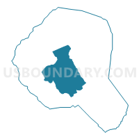
Outline

Summary
| Unique Area Identifier | 560268 |
| Name | 0110010 - HOMER Voting District |
| County | Banks County |
| State | Georgia |
| Area (square miles) | 29.71 |
| Land Area (square miles) | 29.62 |
| Water Area (square miles) | 0.09 |
| % of Land Area | 99.70 |
| % of Water Area | 0.30 |
| Latitude of the Internal Point | 34.33403070 |
| Longtitude of the Internal Point | -83.51797890 |
Maps


Graphs
Select a template below for downloading or customizing gragh for 0110010 - HOMER Voting District, Banks County, Georgia


Neighbors
Neighoring Voting District (by Name) Neighboring Voting District on the Map
- 0110001 - ANDERSON Voting District, Banks County, GA
- 0110003 - BERLIN Voting District, Banks County, GA
- 0110004 - BUSHVILLE Voting District, Banks County, GA
- 0110007 - GOLDEN HILL Voting District, Banks County, GA
- 0110009 - HOLLINGSWORTH Voting District, Banks County, GA
- 0110011 - POPLAR SPRINGS Voting District, Banks County, GA
- 0110013 - WILMONTS Voting District, Banks County, GA
Top 10 Neighboring County Subdivision (by Population) Neighboring County Subdivision on the Map
- Homer CCD, Banks County, GA (5,017)
- Maysville CCD, Banks County, GA (4,366)
- Southeast Banks CCD, Banks County, GA (3,804)
Top 10 Neighboring Place (by Population) Neighboring Place on the Map
Top 10 Neighboring Unified School District (by Population) Neighboring Unified School District on the Map
Top 10 Neighboring State Legislative District Lower Chamber (by Population) Neighboring State Legislative District Lower Chamber on the Map
Top 10 Neighboring State Legislative District Upper Chamber (by Population) Neighboring State Legislative District Upper Chamber on the Map
Top 10 Neighboring 111th Congressional District (by Population) Neighboring 111th Congressional District on the Map
Top 10 Neighboring Census Tract (by Population) Neighboring Census Tract on the Map
- Census Tract 9702, Banks County, GA (5,017)
- Census Tract 9703, Banks County, GA (4,366)
- Census Tract 9704, Banks County, GA (3,804)
Top 10 Neighboring 5-Digit ZIP Code Tabulation Area (by Population) Neighboring 5-Digit ZIP Code Tabulation Area on the Map
- 30529, GA (10,920)
- 30554, GA (8,535)
- 30510, GA (8,291)
- 30558, GA (5,456)
- 30543, GA (4,487)
- 30547, GA (3,268)